Despite the calendar signaling the beginning of summer, Australia experienced an unusual winter-like day on December 1, 2025. A significant cold front swept across the southeastern regions, resulting in snowfall at high elevations in Tasmania, Victoria, and New South Wales. Both Melbourne and Hobart recorded maximum temperatures hovering around just 15°C, temperatures typically associated with winter rather than summer.
"For Melbourne, 15°C is the average maximum temperature in August, the third month of winter," noted a local meteorologist, highlighting the stark contrast to the expected climate of early summer.
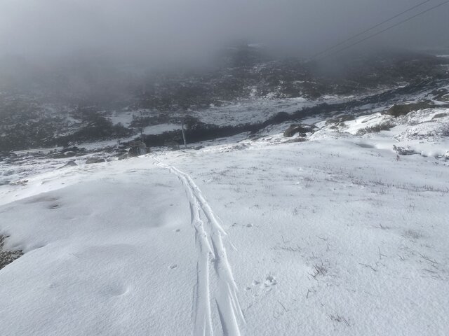
Amidst this unusual weather, Thredbo in the Snowy Mountains of NSW became a temporary winter wonderland, with snow settling as low as 1600 meters. As one local ventured out with skis, they discovered a solid 10 to 15 centimeters of snow accumulation above 1800 meters at Mt Perisher, where snow showers remained persistent.

The phenomenon can be attributed to a feed of moist, cool air from polar regions, which significantly affected conditions in the area. Satellite and radar imagery showed this chill spreading across Tasmania and southeastern Australia.
"Summer snowfalls on the highest parts of Australia are not that unusual," explained a climatologist. It is noted that air masses from polar latitudes typically impact southern Australia at least a few times during the summer months. However, these icy weather systems are generally brief. Melbourne, for instance, is expected to warm up considerably, reaching highs of 28°C by midweek and peaking at around 33°C by Thursday.
The frequency of such polar outbreaks during summer is notably increased during a negative phase of the Southern Annular Mode (SAM), a climate pattern that influences weather in the region. Recent graphs indicated that the SAM has been particularly low over the past twelve months, intensifying the likelihood of cold outbreaks.
While some might speculate that this unusual chill forecasts a cooler summer overall, officials from the Bureau of Meteorology (BoM) caution against drawing definitive conclusions. "It is tricky to predict what will happen this Australian summer due to competing influences," explained Weatherzone meteorologist Ben Domensino. The interplay of a negative SAM and an active La Niña climate phenomenon complicates forecasts further.

The BoM's latest outlook suggests that daytime temperatures will likely remain above average across most of Australia from December through February. Furthermore, they predict that overnight temperatures will also trend warmer than usual, despite the wet conditions typically associated with a La Niña phase. Rainfall patterns are expected to hit both western and inland regions with potential below-average precipitation, while the southern and eastern coasts may have varying chances of above or below average rainfall.
As Australians embrace the peculiar weather patterns at the cusp of summer, the viability of winter sports glimmered at high elevations. Ski resorts may see an unexpected boost in business, as enthusiasts seize the opportunity to ski, with conditions often more reminiscent of winter than summer.
Though the immediate forecast signals a return to warmer temperatures, the contrasting weather on the first day of summer could set the tone for a unique climatic season in Australia. This season of unpredictability offers a distinct experience for residents and travelers alike, standing as a reminder of nature's unfathomable patterns.